Today is Presidents’ Day in the US, so we’ve prepared a week of trivia to honor the American executive branch. All week, we’ll be posting SAR images of famous places named for former presidents. See which images you can identify on our Twitter page then check back here for the answers.
As the first American SAR operator, much of what Capella does today is possible because past presidents worked hard to advance the American space industry. We’re proud of our work with the US Department of Defense and the Intelligence Community, with publicly-announced contracts with agencies like the National Geospatial-Intelligence Agency, National Reconnaissance Office, US Airforce and US Navy. These organizations can use our high-resolution SAR imagery for a variety of purposes, including early indications and warnings of potential threats and humanitarian assistance and disaster relief.
American Presidents and Outer Space
Before we get to the trivia questions, we wanted to share a little presidential history. Over the past several decades, American presidents have played a major role in advancing space exploration and technology in the Earth observation and remote sensing industry.
Here is a spotlight on a few who made significant contributions to this field:
- Dwight D. Eisenhower — In 1955, President Eisenhower approved the first space mission in the US., a scientific satellite called Explorer 1 that would eventually be launched in 1958. That same year, he also approved the Corona program, the first operational space photo reconnaissance satellite.
- George H.W. Bush — In 1989, President H.W. Bush proposed the idea for Mission to Planet Earth. This NASA mission centered around launching a network of satellites to observe Earth and monitor climate change.
- Bill Clinton — For several decades after President Eisenhower approved of the Corona program, reconnaissance satellite data was considered classified by the US government. In 1995, President Clinton changed that, signing an executive order to declassify satellite imaging technology for commercial purposes. As a result, imagery captured by the Corona, Argon, and Lanyard satellite missions was transferred to the National Archives and Records Administration.
- Barack Obama — For years, the US enforced a 0.5-meter resolution limit on commercial satellite imagery, which was stricter than other limits around the world. In 2009, President Obama lowered the commercial resolution limit to 0.25 meters, which allowed American satellite companies to remain competitive on the world stage.
Presidents’ Day Trivia Answers
We hope you have enjoyed guessing the locations of our president-related SAR images this week. You can take a look at the answers below. We’ll keep updating this post throughout the week as we share new images on Twitter. How many did you get right?
Thursday
The SAR Image:

The Location: Monrovia, the capital city of Liberia on the west coast of Africa
Monrovia, Liberia was named in honor of President James Monroe as a settlement for freed slaves. This high-resolution SAR image focuses on the city’s Sinkor district on the Atlantic coast. Tubman Boulevard is clearly seen as a darker area in the image, extending along the Mesurado Peninsula. Balli Island can be seen in the Mesurado wetlands.
Wednesday
The SAR image:
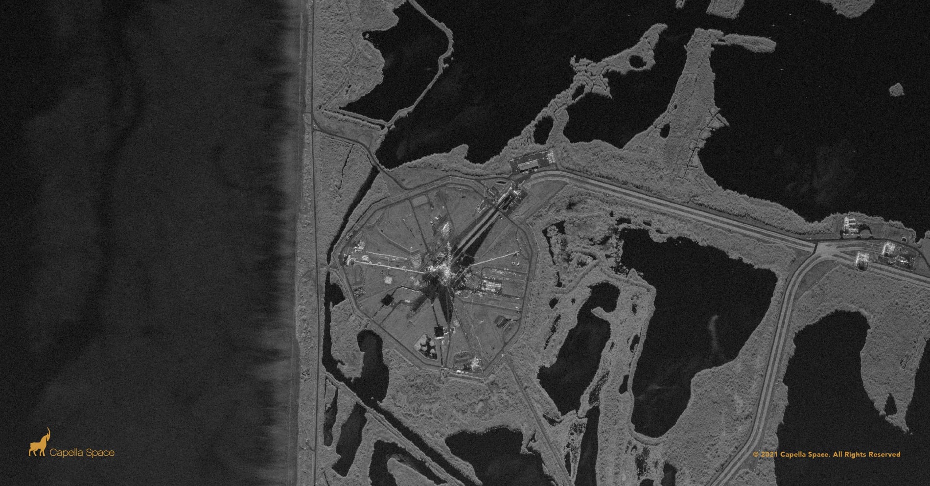
The Location: John F. Kennedy Space Center, Merritt Island, Florida
Capella’s high-resolution Spot imagery clearly images Kennedy Space Center Launch Complex 39A. The image shows a contrast between the wetlands of Merritt Island and the pad which has hosted the Apollo program, the Space Shuttle program and SpaceX commercial cargo and crew missions.
Tuesday
The SAR image:
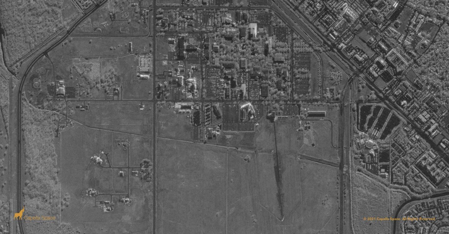
The Location: Lyndon B. Johnson Space Center, Houston TX
This SAR image of the Lyndon B. Johnson Space Center has imaged the 100 buildings of the complex, used for human spaceflight training, research and flight control. Capella’s Spot imagery provides high-resolution, all-weather visibility with a 5km x 5km swath, which includes the nearby apartment complexes, hotels and hospital lining NASA Road 1.
Monday
The SAR image:
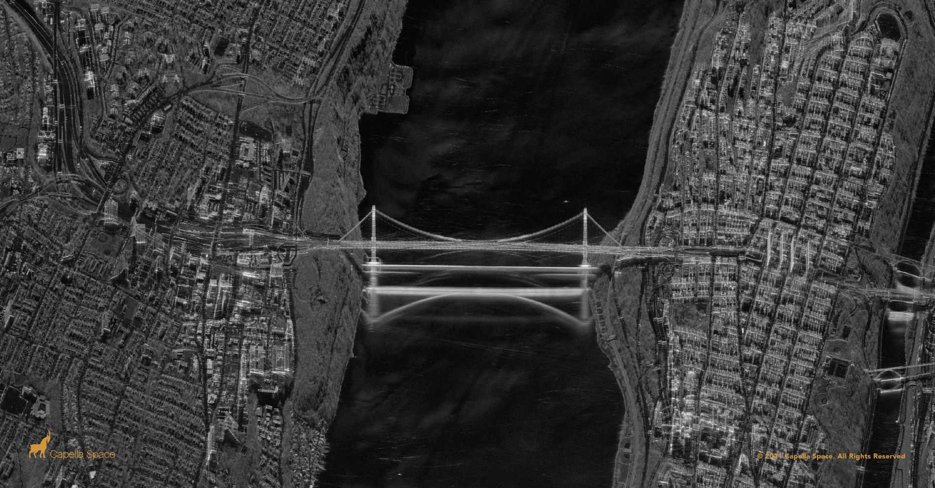
The Location: George Washington Bridge — Hudson River, Manhattan, NY, and Fort Lee, NJ
The George Washington Bridge connects Washington Heights in Manhattan and Fort Lee, New Jersey along the approximate evacuation route used by the Continental Army in 1776. The 14-lane, double-decked suspension bridge is clearly defined in our high-resolution Spot imagery. The granular features such as the deck, cables and suspension towers are easily identifiable, demonstrating why high-resolution imagery is a powerful tool for infrastructure monitoring.
While water scatters away radar energy resulting in dark surfaces, the George Washington Bridge appears to reflect in the water due to SAR multi-path as the signal bounces from the object to the water and back to the sensor.
