Capella Space
Blog
April 22, 2021
Earth sits at the heart of our mission at Capella Space. Since 2016, we’ve worked hard to deliver on our vision of providing customers with access to very high-resolution SAR data that gives them near real-time visibility anywhere on the planet. One of the compelling use cases for our technology is to monitor the natural and human-made activities that impact Earth, including the impacts of climate change and the conservation and green infrastructure development efforts focused on reducing those impacts.
The theme for Earth Day this year is “Restore our Earth,” emphasizing the emerging green technologies that can help restore our ecosystems. All around the world, governments, companies, and even individuals are doing their part to build green infrastructure that provides clean energy. To celebrate Earth Day, we used our satellite constellation to capture high-resolution SAR imagery of some of the biggest solar panel and wind turbine farms around the globe.
Like any energy infrastructure project, large wind and solar farms require site assessments before, and monitoring during, their construction. In addition, they require ongoing infrastructure, easement, and site inspection to ensure safety and reliability in their operations. Considering the size of the facilities themselves and the transmission infrastructure needed to provide electricity to homes and businesses, our imagery offers significantly more than a beautiful representation of green energy at work. Capella’s all-weather, near real-time SAR can provide efficient and cost-effective monitoring to reduce the cost of operation and understand the impact of encroachment, storms, and other events that can disrupt power generation and transmission.
For Earth Day, we imaged some of the largest green infrastructure projects on the planet in high-resolution all-weather SAR. The imagery looks stunning but also serves as a reminder of the financial and logistical challenges we will need to overcome in a transition to green energy.
Solar Panel Plants

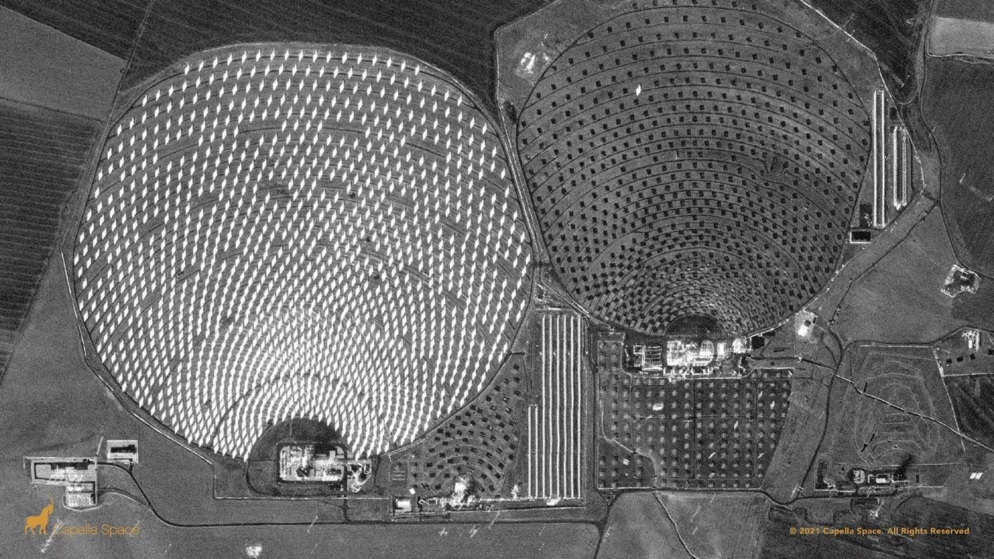
The PS10 Solar Power Plant in Seville uses angled mirrors to heat molten salt towers, generating energy. The bright panels in the western farm can provide contextual clues regarding the panels’ orientation, as radar energy from the Capella satellite is reflected back from the surface. In contrast, shadowing on the eastern farm indicates the mirrors are tilted away from the satellite.

This nighttime SAR image shows sections of the Kurnool Solar Ultra Mega Park, a 24 square mile solar farm with over 4 million flat photovoltaic (PV) panels. Kurnool Park has the world’s largest collection of solar panels and can produce 1,000 megawatts of carbon-free electricity.
This image shows the vast field of arrays at the Villanueva Solar Plant in Coahuila, Mexico. With a 754-megawatt capacity, this plant was developed in two phases, completed in March 2018 with an estimated cost of $650M. The plant generates enough power for 1.3M households in Mexico.
Wind Farms

The Mojave Wind Farm, also known as the Alta Wind Energy Center, in Kern County, California is the world’s third-largest onshore wind energy project. Capella’s SAR imagery can visualize individual wind turbines’ operational status, as the satellite captures motion in 9 separate images averaged together in a “multi-look.”

This SAR image shows a section of the Gansu Wind Farm Project, the world’s largest wind turbine farm. Construction began in 2009 and has progressed in phases undertaken by multiple developers. Monitoring progress of large development efforts in remote areas is one of many applications where SAR data can be used to help customers understand the renewable energy landscape. Clusters of the farm’s 7,000 wind turbines and massive electrical transmission lines are clearly visible in 50 cm SAR imagery.

This SAR image shows some of the 365 wind turbines in Kenya’s operational Lake Turkana Wind Power Station, commissioned in late 2018. The project suffered delays in development, which led to the World Bank’s eventual withdrawal. Monitoring project development status and providing measurements such as the current number of standing turbines or changes in site activity, can be valuable to international investors, partners, and other stakeholders.
Interested in how SAR can help monitor energy infrastructure at scale? Contact us to learn more.
Curious Which Of Our Analytics Partners
Can Support Your Mission?
Contact our team to explore the possibilities. Our experts can help
you determine the optimal solutions for your unique needs.

Keywords
.png)
Stay Informed. Stay Ready.
Get briefings on new capabilities, technology improvements, and upcoming events.


.avif)
