Duncan Quincey
Case study
May 9, 2022
The following is a guest post from Duncan Quincey, Professor of Glaciology at the University of Leeds. Duncan uses Capella’s high resolution SAR imagery to study the effects of climate change on glacial melt, which can have a significant impact on local ecosystems as well as drinking water supply levels. Learn more about his latest research around the Himalaya below, and you can follow him on Twitter at @duncanquincey.

Glaciers and snowpacks of the Himalaya provide the ultimate source for some of the world’s largest rivers. It is estimated that up to a quarter of the global population rely in some way on these ‘water towers’, which ultimately flow into the Asian subcontinent supporting hydropower and industry, as well as being a vital irrigation and even drinking resource for communities in the foothills. In line with climatic warming, however, these snow and ice reservoirs are undergoing rapid change – melt seasons are extending, ponds are expanding, and even areas known to be stable in recent decades have entered a period of ice recession. The University of Leeds has been working with Capella Space to chart some of the surface changes to establish a baseline dataset against which future observations can be compared.
The Karakoram, which sits to the west of the Himalayan range, and covers parts of north-west India and northern Pakistan, is one of the very few glacierized regions of the world that has been accumulating more ice mass than it has been losing in recent decades. It is home to some of the largest glaciers outside the polar regions, and melt from these glaciers (as well as high-elevation snowpacks) feed into the Indus River, maintaining flows during periods that may otherwise be at risk of drought. Recent data shows that this period of positive balance is over, and that the Karakoram is also now in recession, meaning the previously reliable flow of water may now be under threat.
Glaciers are particularly adept at storing water supplies that fall (usually as snow) during the rainy season, and releasing them as melt during the dry season. It is possible to chart these melt seasons through the changing surface characteristics of the glaciers. The seasonal cycle of surface ponds filling and draining is evidence of when the glacier has warmed sufficiently to generate surface melt, and is a useful barometer or proxy for how rapidly this is occurring year over year. Karakoram glaciers are also known for their often erratic behavior, and have a long history of blocking river channels, creating meltwater lakes, and releasing large volumes of water unexpectedly, flooding downstream areas and threatening vital infrastructure.
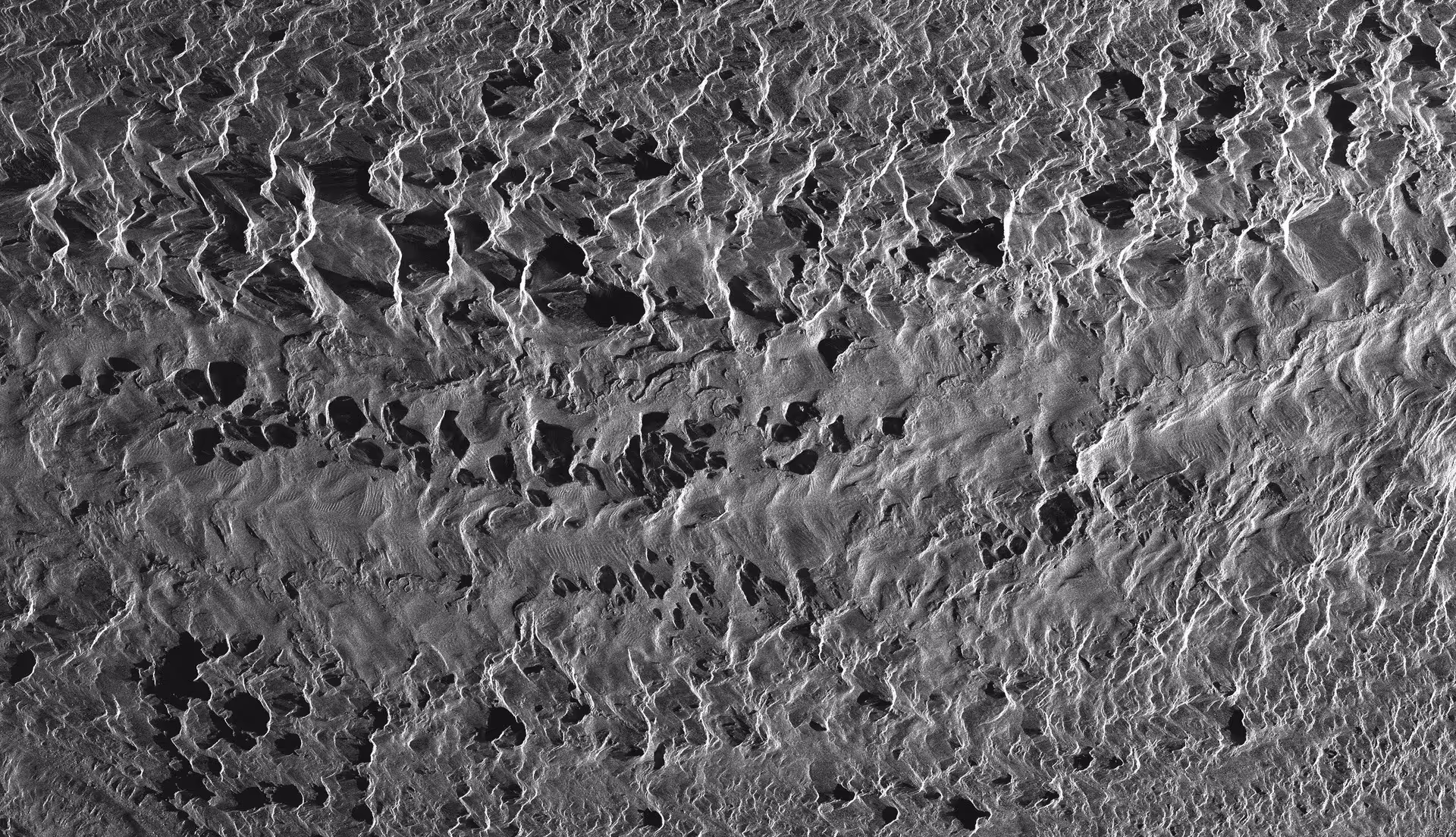
Observing these changes with optical imagery is often thwarted by persistent cloud cover and frequent snowfalls, but with Synthetic Aperture Radar (SAR), we are able to capture these changes through these challenging weather patterns. The University has worked with Capella Space to task images of several key glaciers, including the Baltoro Glacier in the Karakoram, and the Khumbu Glacier in Nepal, so that researchers in the School of Geography can track the seasonal cycle of pond filling and drainage, as well as measure glacier flow rates that can indicate whether a glacier is warm enough to maintain meltwater at its base.
As the image here shows, even small surface streams become visible to the naked eye at the level of detail afforded by Capella's sensors. This capability offers the potential for year-round, uninterrupted monitoring of glacier meltwater dynamics for the first time. The characterization of different debris-covers provides an important dataset for numerical modelers aiming to simulate surface melt rates. And the identification of ice-sails – a particular quirk of the Baltoro Glacier – gives insight into one of the least studied phenomena in any realm of glacial geomorphology.
With precision imaging from Capella SAR satellites, it is now feasible to chart the response of debris-covered glaciers to climatic changes, as well as to generate quick and accurate assessments of anomalous glacier behavior.
For more information about Capella’s high-resolution imagery products, visit https://www.capellaspace.com/data/sar-imagery-products/.
Curious Which Of Our Analytics Partners
Can Support Your Mission?
Contact our team to explore the possibilities. Our experts can help
you determine the optimal solutions for your unique needs.

Keywords


Stay Informed. Stay Ready.
Get briefings on new capabilities, technology improvements, and upcoming events.


.avif)
