Back to Resources
Blog
Our Latest First Light Images Showcase UNESCO World Heritage Sites in Central and South America
Capella Space
Blog
March 2, 2022
We kicked off 2022 by adding two more satellites to our constellation after launching with SpaceX’s Falcon 9 rocket. With these new satellites, we will significantly increase our total imaging capacity, ensuring we can support customers capturing imagery in locations where we are seeing high demand for SAR. By growing our constellation, we’re increasing our responsiveness and further expanding the number of locations we can monitor simultaneously across the globe. This will help us automate change detection over time, identify specific features and patterns of life, and rapidly validate analytics results through precision tasking.
We’re excited to share some of the first images we collected from our two newest satellites. The high-resolution SAR images below are all UNESCO World Heritage Sites located in Central America and South America. A major advantage of SAR technology over optical satellite imagery is that SAR images can be captured in all weather and light conditions, providing 24/7 imaging capacity. Our new satellites captured the images below in both cloudy and dark conditions. As you can see, the images are all incredibly clear and show off these beautiful, culturally significant World Heritage Sites.

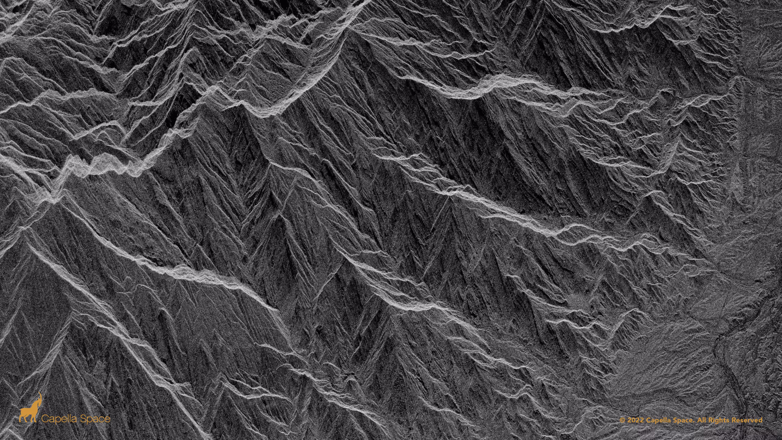
This image shows a section of Talampaya National Park in Argentina, which was designated a UNESCO World Heritage Site in 2000. Our SAR satellite image was captured close to the border between the adjacent Talampaya National Park and Ischigualasto Provincial Park, both part of a desert region on the western border of the Sierra Pampeanas mountains. The distinctive geological formations in the park are shown here in sharp detail. The park’s red sandstone cliffs reach 200 meters in height and are considered to be of enormous scientific importance. Throughout the park, the cliffs contain one of the most complete continental fossil records on the planet, including fossils of mammals, dinosaurs and plants.

This SAR image of Canaima National Park, declared a UNESCO World Heritage Site in 1994, was captured on January 20, 2022 at 10:15 pm local time. This national park spreads over 3 million hectares in southeastern Venezuela along the border between Guyana and Brazil. Throughout the year, Canaima National Park is covered by clouds between 65%-79% of the time. While optical satellite imagery is limited to daylight hours and clear weather conditions, Capella’s SAR technology can capture imagery at night and through heavy cloud cover. In this image, the Karwai River is visible, as well as the park’s distinctive table mountain formations and dense forest.

Pictured here is the caldera of La Cumbre Volcano on Fernandina Island in Galápagos National Park. La Cumbre is the most active volcano on the Galápagos Islands, erupting most recently in January 2020, about a year before this image was captured. The caldera of the volcano is about 6.5 kilometers wide. UNESCO declared the Galápagos a World Heritage Site in 1978. During active volcanic eruptions, Capella can use microwave remote sensing to monitor volcanoes even through miles of volcanic smoke.

Machu Picchu, located 2,430 meters above sea level on the eastern slopes of the Andes Mountains in Peru, is probably one of the most famous and recognizable sites in the world. It became a World Heritage site in 1983. Machu Picchu is located in a cloud forest, which is a tropical forest covered by a dense layer of fog at the canopy level. SAR technology is ideal for capturing imagery of cloud forest regions because SAR sensors capture data regardless of weather conditions.

The Guanacaste Conservation Area is located in northwest Costa Rica. The area encompasses a diverse variety of topographies and ecosystems, including coastal lowlands, wetlands, dry forest, savannah, and the western side of the Guanacaste Range. In this high-resolution SAR image, you can see a mixture of many kinds of topography in the center of the image.
If you enjoyed these images, sign up to access our Open Data Gallery for more. We have additional launches planned to serve customer needs, so make sure to follow us on Twitter for updates on the continued expansion of our constellation.
Curious Which Of Our Analytics Partners
Can Support Your Mission?
Contact our team to explore the possibilities. Our experts can help
you determine the optimal solutions for your unique needs.

Keywords

Stay Informed. Stay Ready.
Get briefings on new capabilities, technology improvements, and upcoming events.


.avif)
