Capella Space
Product guides
May 8, 2020
Note: this is the first of a two-part blog series; in the second post I will discuss our online platform, which will make it easier to access SAR data and will provide useful resources for our developer community.

Over my career in the geospatial industry, I have always believed that synthetic aperture radar (SAR) has enormous untapped potential to solve market needs – there are countless applications that would benefit from a 24-hour all-weather Earth observation imaging capability. There are a wide variety of vertical market use cases that benefit from SAR’s unique capabilities, including persistent monitoring of facilities for defense & intelligence, verifying damage claims for insurance, detection of illegal activities for maritime, mapping natural disaster damage for humanitarian aid and infrastructure security for oil & gas (just to name a few). However, the adoption of SAR has always been very limited in comparison to other remote sensing modalities since SAR imagery is often difficult to obtain and requires advanced technical expertise to interpret or exploit the data. In order to unlock the potential value of SAR we need to make the data more accessible, provide imagery or derived products that are more suitable for real-world applications and simplify the overall user experience.
At Capella Space our mission is to provide hourly monitoring from space and we are going to unlock SAR’s potential value by focusing on the following core competencies:
- Frequent (high-cadence revisit timeframes)
- Timely (rapid automated order-to-delivery)
- Quality (very high resolution and radiometrically enhanced)
- Accessible (intuitive self-serve customer experience)
In our previous blog posts we have discussed how Capella Space is transforming the Earth observation industry by building a constellation of advanced SAR satellites and ground segment infrastructure with a suite of technological innovations. This, coupled with our partnership with Addvalue and Inmarsat, allows Capella to provide high-cadence revisit, on-demand new acquisition tasking and the fastest order-to-delivery times available in the market. On their own, frequent revisit and rapid delivery do not in themselves make a significant impact, unless the SAR imagery is high quality and easily accessible via self-serve online access. Consequently, the Capella engineering team has designed a SAR sensor that will produce very high resolution (VHR) satellite imagery and an online platform (web application + API) to explore our existing archive catalog and submit tasking requests for new imagery acquisitions.
These technological developments enable us to achieve the aforementioned core competencies, but customers do not consume technologies directly; they need off-the-shelf product offerings and turnkey solutions that help their business or organization be more successful. Consequently, this two-part blog post series will discuss our advanced SAR imagery data products and intuitive self-serve online platform which will allow our customers to increase their productivity, profitability and mission success.

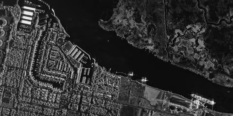
Throughout this blog post you will see imagery from Capella’s recent airborne campaign which was flown over the Bay Area in California. The airborne campaign produced a collection of simulated datasets using the same SAR sensor design that will be on our satellites (but mounted in an aerial platform). The radar system used in the Bay Area campaign is nearly identical to the SAR sensor that will fly on our operational satellites. These SAR images have been processed to a specification, format, resolution, quality and noise level that aligns with the expected performance of our satellite-based SAR sensors.
Capella’s satellites can operate in three SAR imaging modes as illustrated in the diagram below. From these imaging modes we will initially offer both single-look-complex (SLC) and geocoded terrain corrected (GEO) image products. The “SLC” image product provides both amplitude and phase of the radar signal which is suitable for InSAR processing techniques such as Coherent Change Detection (CCD). The “GEO” image product utilizes the magnitude information to generate a surface reflectivity image which leverages Capella’s advanced multi-looking technology to obtain radiometrically enhanced images. Capella’s SAR imagery products will be delivered in standard file formats such as cloud-optimized GeoTIFF and SICD that can be easily opened into common GIS or ELT geospatial software applications.

An important performance metric for Earth observation imaging capabilities is spatial resolution, since it provides the ability to distinguish small targets that are close to one another. Furthermore, since SAR data is always acquired with a side-looking acquisition geometry, the spatial resolution performance cannot be effectively characterized by a single distance value. Instead, for SAR there are actually three separate dimensions that must be considered – slant range, ground range and cross range (which is typically referred to as “azimuth”). For SAR imaging, the spatial resolution in each of these dimensions is almost always slightly different and can vary from image to image based on collection parameters, such as incidence angle and dwell time over the area of interest.
Capella’s SAR system is optimized to operate with a transmitter bandwidth of 500 MHz, which can provide 30 cm effective slant range resolution (i.e. in the propagation direction of the microwave) for the single-look complex (SLC) image products. When the slant range resolution is projected to the ground plane, SAR imagery products with a ground range resolution of 50 cm can be generated. Furthermore, the agile design of the Capella satellite provides much longer dwell times which results in centimeter-scale azimuth resolution in the along-track direction. The commercially available SAR imagery products acquired in the spotlight mode are multi-looked to align the azimuth resolution with the ground range at 50 cm. The resulting geocoded (GEO) image product is gridded with a finer pixel spacing size of 25 cm in order to retain the full 50 cm ground plane resolution performance in each dimension.

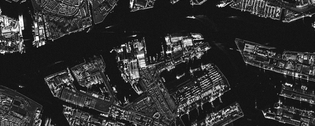
However, spatial resolution is only one of many performance factors that contribute to the overall quality and usability of SAR imagery, which is impacted by a blend of multiple image acquisition and production characteristics. The agility of Capella’s spacecraft allows for longer dwell times over the same scene than typical SAR systems. The longer dwell times in our spotlight mode enable our enhanced multi-looking technique, which reduces speckle and improves image clarity while retaining spatial resolution performance. Capella’s advanced multi-looking process produces enhanced radiometric resolution with higher sensitivity to brightness changes and less noise. As illustrated in the figure below, the Capella multi-looked image has improved quality and reduced speckle, which improves visual interpretability and enables novel automated exploitation that is not possible with typical SAR imagery.

In addition to collecting individual scenes, our constellation will also be capable of imaging larger areas of interest (AOIs) and acquiring multiple images over the same region with identical collection parameters. Consequently, with Capella’s frequent revisit, we will be able to generate deep temporal image stacks that are ideal for automated change detection and AI machine learning applications. To enable the development of machine learning algorithms that automatically extract derived information and actionable insights from SAR data, Capella has contributed a collection of these airborne campaign datasets to the SpaceNet 6 challenge focused on multi-sensor all-weather mapping.

In summary, the airborne SAR images in this blog post speak for themselves with the very high spatial resolution and exceptional radiometric quality that will be available from our upcoming satellite constellation. This unmatched quality, in combination with our frequent revisit, timely order-to-delivery and simplified user experience, is how Capella plans to unlock all of SAR’s untapped potential. If you are interested in learning more about Capella’s advanced SAR imagery products please get in touch as we’d love to hear how our solutions could help your business or organization be more successful.
Curious Which Of Our Analytics Partners
Can Support Your Mission?
Contact our team to explore the possibilities. Our experts can help
you determine the optimal solutions for your unique needs.

Keywords

Stay Informed. Stay Ready.
Get briefings on new capabilities, technology improvements, and upcoming events.


.avif)
