Raphael Grandin
Case study
December 22, 2022
From 19 September to 5 October 2022, a volcanic eruption took place on the flanks of Piton de la Fournaise volcano in the Indian Ocean. Emerging from an open fissure, molten lava traveled downslope for more than 3 km in two weeks. Efficiently predicting the probable pathways of the lava flow is essential for the safety of volcanologists on the ground. This requires detailed and frequent observations of the advancing front of the lava flow. A partnership between Capella Space and remote sensing scientists provides daily Synthetic Aperture Radar (SAR) observations to volcano observatories, allowing them to anticipate the dynamic processes along the lava flow. Synergy between spaceborne and on-the-ground monitoring paves the way for new strategies to better protect communities threatened by volcanic hazards.
Volcanic eruptions reshape the Earth's surface, creating dramatic landscapes that generate favorable conditions for the development of unique ecosystems, both on land and under the ocean surface. On the other hand, volcanoes represent a major hazard for vulnerable populations living on their flanks.
Among the many challenges in monitoring volcanoes, a source of concern for volcanologists working in observatories is the prompt identification of rapid transitions between a state of quiescence and the triggering of an eruption. Furthermore, when a state of eruption is declared, maintaining a steady level of oversight of the evolving situation may become complex, especially when surface conditions deteriorate. The capability to observe the surface using radar imagery, regardless of weather or illumination conditions, is now becoming a strategic part of volcano monitoring.
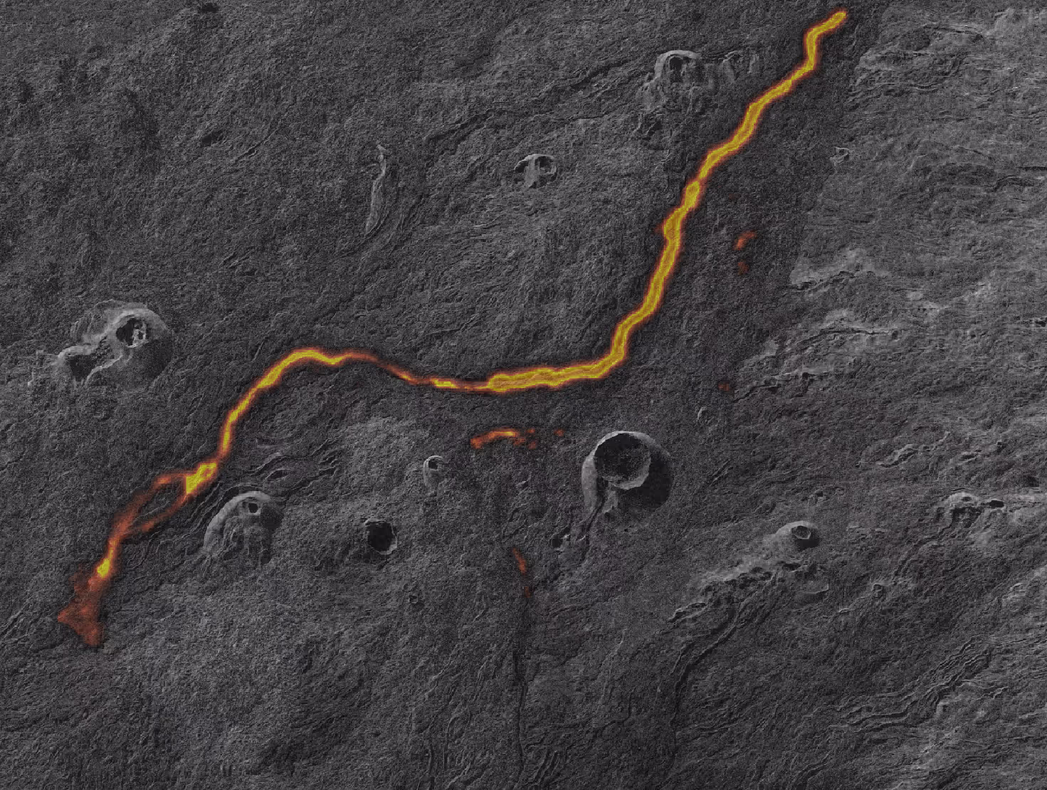
On 19 September 2022, the Piton de la Fournaise volcano (Indian Ocean) generated a spectacular lava flow that traveled down the volcano's slopes. The emission site was first witnessed as an open fissure, producing spectacular lava fountains. Alerted by observatory volcanologists, remote sensing scientists tasked the Capella satellites to track the morphology of the volcanic constructs during the eruption. A comparison of Capella imagery acquired in January 2022, before the eruption, allows for measuring the size of the cone, with an inner diameter of ~ 100 meters and a height of ~20 meters.
Thanks to sub-metric pixel size, Capella’s SARimagery also shows the active lava channels in great detail, which enhances the mapping of the lava flow conducted daily by volcanologists, complementing traditional approaches relying entirely on optical imagery. Capella imagery shows how lava is paradoxically not visible at the surface within ~400 meters of the vent. Beyond this distance, an active lava flow emerges at the surface, indicating the presence of an underground lava tunnel that stealthily conveys lava down the volcano's slope and feeds the flow. These lava tunnels represent a major danger for volcano observatory staff, who need access to the field during an eruption for instrument maintenance or lava sampling. Quickly identifying these tunnels, and tracking their stability, is crucial for the safety of personnel. "Tracking lava flows in real time using radar imagery is crucial for the safety of our staff," says Dr. Aline Peltier, head of the Volcano Observatory of Piton de la Fournaise (OVPF). "These capabilities will be transformative for disaster recovery efforts and enhance situational awareness for researchers or scientists who cannot reach hazard sites."
As volcanic environments often combine remoteness and extreme meteorological conditions to limit observational gaps, volcanologists are building new strategies for jointly monitoring volcanoes both from the ground (using geophysical or geochemical instruments), and from Earth's orbit. Capella’s constellation of all-weather sub-meter resolution SAR satellites offers the United States Geological Survey (USGS) Volcanoes Program a unique tool set that will play a pivotal role in helping advance our understanding of volcanic hazards.
For more information about the volcanic activity of Piton de la Fournaise volcano, visit the OVPF web page at https://www.ipgp.fr/fr/ovpf/actualites-ovpf, or follow the OVPF on Facebook or Twitter.
To learn more about how SAR can help volcanologists gaining a better understanding of volcanic eruptions, contact Capella today.

Curious Which Of Our Analytics Partners
Can Support Your Mission?
Contact our team to explore the possibilities. Our experts can help
you determine the optimal solutions for your unique needs.

Keywords
.png)
Stay Informed. Stay Ready.
Get briefings on new capabilities, technology improvements, and upcoming events.


.avif)
