Capella Space
Blog
July 10, 2020
While Capella’s New Space approach to monitoring the planet is novel and innovative, Earth observation generally has been in practice since the 1960s. Hundreds of satellites have been launched to take images for a variety of purposes, such as meteorology, maritime and land surveillance, government reconnaissance and more. There are two ways satellites can conduct remote sensing. The first is with passive sensors, such as electro-optical (EO) sensors and camera systems. The second is with active sensors like radio detection and ranging (radar).
Synthetic Aperture Radar (SAR) technology leverages a radar system installed on a moving platform to generate two-dimensional images of the surface of the earth. SAR actively illuminates the ground and uses the motion of the radar antenna over a target region to provide finer spatial resolution than conventional radar. SAR technology offers many advantages that traditional EO sensors can’t provide. In fact, high resolution imagery is just one of many derived products that can be produced from SAR data processing. Here are a few of the advantages of using SAR for earth observation:
24/7 reliable monitoring
EO sensors typically depend on solar illumination, which means the information they can provide at night is very limited. The wavelengths captured by most EO systems also are not able to penetrate well through cloud or hazy atmosphere. Typically, EO sensors are launched into sun-synchronous orbits where they pass over targets at the same time in the morning to avoid cloud formation.
Because SAR systems are self-illuminating and the wavelength used can penetrate clouds, fog, smog, darkness and smoke, they can be effectively used in a variety of polar or inclined orbits to increase the diversity of observation times. This orbit diversity and ability to see through any atmospheric conditions allows SAR to collect images at any time of day or night. It also ensures that users of SAR can reliably and consistently monitor their areas of interest.
This ability is critical because our need for accurate Earth observation doesn’t stop when we go to sleep, or when the weather is not good. For example, if there is a hurricane and the streets in a city start to flood, there is a dire need to understand what is happening on the ground regardless of time of day or clouds. Disaster response crews still need to be able to identify which roads have flooded and where damage has occurred to accurately plan and execute their recovery efforts.
Precise, high-resolution imagery
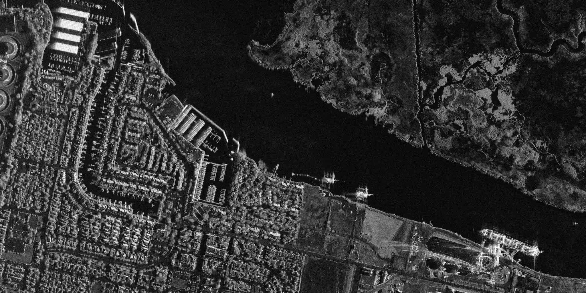
Over the years, scientists have experimented with different wavelengths for SAR. While there are different advantages to using different wavelengths, Utilizing X-band microwaves and large bandwidth makes it possible to achieve excellent ground range resolution. With the use of the synthetic aperture principle, it is also possible to achieve very high resolution in the azimuth direction. In other words, the imagery from X-band SAR satellites can be incredibly detailed and can detect and map small objects, like vehicles, with high accuracy. The high resolution of X-band SAR and excellent contrast achieved through a process called multi-looking can yield imagery that is uniquely suitable for object detection and recognition using computer vision and machine learning.
Imagery on-demand
SAR satellites and constellations are typically agile, with an ability to image from different directions and viewing angles. This flexibility can enable more frequent imaging of targets on the ground with fewer satellites. Although some current SAR satellites are using outdated systems that make it difficult for end-users to interact with them in real-time, newer, innovative SAR constellations will have the capacity to offer a very rapid system response time from tasking to imaging and delivery through automation, which means customers will receive data they request very quickly. Constellations can provide data particularly quickly when they take advantage of a dense global network of ground stations, powerful computing, and automated processes to minimize time-consuming human interactions.
Accurate elevation models
SAR systems also provide a unique ability to accurately characterize topography and surface features in 3D. This can be accomplished through use of bistatic imaging with two satellites flying in formation, or an approach called radargrammetry to create three-dimensional images. Accurate elevation and surface models are useful for a number of industries. For example, detailed terrain and surface models can be used for analyzing line-of-sight for communication towers or for modeling water flow in watersheds. Frequently updated surface models can also be used to help autonomous vehicles navigate around flight path obstructions.
Reliable global change monitoring in 3D
SAR sensors can detect changes on the surface of the earth over time through a variety of advanced techniques. Amplitude change detection looks for differences in the intensity of reflected radiation between images of different dates. Coherent change detection is unique to SAR and leverages the phase information of the returned signal to detect more subtle changes on the surface of the earth, like new tire tracks on a dirt road or emergence of a crop in a newly planted field. Combined with the 24/7 all-weather monitoring nature of SAR and frequent imaging, these change detection approaches ensure that new activity within an area of interest can be responded to rapidly.
Deformation monitoring with Interferometry can reveal change in the vertical dimension and is sensitive to millimeter-scale change. A SAR satellite constellation can enable the potential to do these measurements daily (or even more frequently), with automated alert notifications when change happens in areas of importance that are being monitored. This allows customers to know the moment an essential piece of infrastructure starts to move. Even a small amount of subsidence or uplift can indicate risk to infrastructure. Accurate and frequent alerts are critical so city governments, factory owners, power plant operators and other key stakeholders can respond rapidly and reduce liability.
SAR constellations are key to enhancing Earth observation.
From 24/7 availability to high levels of precision and accuracy, SAR technology opens the door to new innovations and Earth observation applications. To learn more about SAR data, please check out our SAR 101 and SAR 201 blog posts. If you’d like to get hands-on experience with SAR data, please sign up to join our SAR Community and access open license Capella SAR data: capellaspace.com/community.
Curious Which Of Our Analytics Partners
Can Support Your Mission?
Contact our team to explore the possibilities. Our experts can help
you determine the optimal solutions for your unique needs.

Keywords
.jpg)

Stay Informed. Stay Ready.
Get briefings on new capabilities, technology improvements, and upcoming events.


.avif)
