Capella Space
Blog
April 21, 2026
.jpg)
In January, Capella, an IonQ company, launched two new Acadia Synthetic Aperture Radar (SAR) satellites, Capella-18 and Capella-19 aboard SpaceX's Falcon 9 Twilight mission into sun-synchronous orbit – now operational. Constellation expansion at Capella is more than adding satellites to a fleet, it also means delivering new capabilities.
Each new satellite increases not only collection capacity, but our constellation’s ability to return to the same location with the precision required for consistent, long-term monitoring. This is what transforms individual images into usable intelligence over time.
However, the value of SAR imagery isn’t determined by fleet size alone. Monitoring requires showing up to the same place, from the same angle, on a repeatable schedule. That’s a harder engineering problem, and not every constellation is built to solve it. Capella’s is.
Today, we’re pleased to introduce the latest capability with the Capella constellation: repeat-track orbits. Repeat-track orbits ensure satellites revisit the same location from nearly identical viewing positions over time, enabling consistent comparisons. This provides consistent imaging geometries and turns SAR data into a foundation customers can build long-term monitoring programs around.
Why Orbit Control is a Mission-Critical Capability
SAR satellites can collect imagery anywhere. What separates an imaging asset from a monitoring program is whether the satellites come back to the same place, and whether analysts can trust that it will.
Consider post-earthquake response. In the hours and days after a seismic event, deformation mapping tells responders which structures are compromised, where subsidence (ground sinking) has occurred, and where aftershock risk is highest. That analysis depends on consistent monitoring – ideally begun before activity escalates, to compare a post-event SAR image to a pre-event baseline collected from nearly identical geometry. If the orbit drifts between passes, the value of SAR data degrades.
The data arrives. The intelligence doesn’t.
This is the constraint that interferometric SAR (InSAR) makes explicit. InSAR is a technique that compares phase (signal timing differences) between multiple radar images of the same location to detect extremely small surface changes. InSAR works by comparing phase differences across two or more images of the same scene, taken from identical viewing geometries. The satellite must come back to the same position, at the same angle, every time. Without that, you have a snapshot. With it, analysts can detect millimeter-scale surface change: subsidence, structural shift, and seismic deformation that no other sensor resolves.
The same logic extends beyond acute events. A dam shifting two millimeters per year is not a crisis, but tracked consistently, it becomes a signal. Once orbital geometry becomes inconsistent, that signal becomes unreliable. A satellite orbit isn’t just a technical parameter. It’s the foundation of the product.
The Physics of Consistency: Maintaining the 500-Meter Tube
When a satellite revisits the same orbital position with sufficient precision, analysts can use interferometric SAR data to extract millimeter-level surface deformation. This includes subsidence of critical infrastructure, landslide precursor detection (early warning signs of slope failure), seismic deformation mapping, and long-term settlement analysis.
That poses a hard constraint. A spacecraft must return to within a tightly bounded orbital tube – a precise corridor in space defined by a fixed reference trajectory (the intended orbital path) – reliably, pass after pass, across years of operation. The tighter the tube, the more consistently interferometric data becomes intelligence.

Capella's Acadia constellation has demonstrated long-term sustained operations within a 500-meter tube consistently on commercially operated, highly agile small satellites executing dense imaging schedules for diverse customers simultaneously. Capella-18 and Capella-19 achieve this level of orbital precision in part through the integration of Orbion's Aurora electric propulsion systems, which provide the fine, repeatable control required to maintain consistent repeat-track orbits over time. Unlike traditional chemical propulsion, electric propulsion uses electromagnetic forces to accelerate ions, enabling highly efficient, low-thrust operation that can be applied continuously for precise orbit shaping and maintenance. This allows satellites to counteract atmospheric drag, correct orbital drift, and make subtle adjustments with exceptional accuracy. The result is a spacecraft that can reliably return to the same position and viewing geometry on every pass - turning orbital consistency into a dependable foundation for high-quality, time-series SAR data. This means satellites return within 500 meters of their intended orbital path over time. When Capella returns to a target, it returns to the position that makes the data usable.
Case Study: Orbital Precision in Practice Over Mexico City
Capella’s repeat ground track orbits are what makes time-series InSAR viable at commercial scale. Using 18 X-band SAR scenes collected at 3-day intervals over ~50 days, Capella's C14 satellite produced high-coherence interferometric data. High coherence refers to the consistency of radar signal returns between images, which is critical for accurate comparison. The data was precise enough to detect subsidence rates within ~1 cm/year and point heights within 0.25 m RMS (root mean square, a standard measure of error) – over one of the most rapidly subsiding urban environments on Earth.
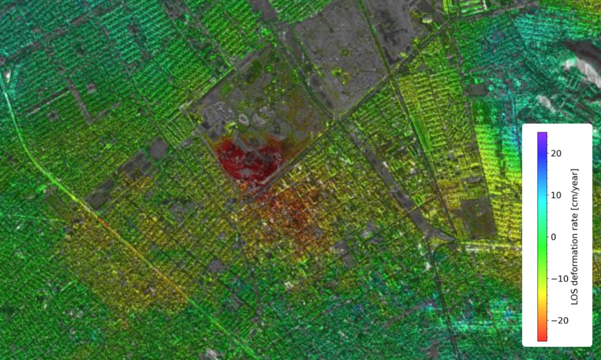
The consistent spatial baselines (the relative distance and geometry between satellite passes) achieved over Mexico City aren't a byproduct of luck; they're the result of a constellation engineered to return to the same orbital position, pass after pass, with enough precision to support coherent interferometric stacking (combining multiple radar images to improve signal quality and extract change over time).
Learn more about Capella’s InSAR and PSI Case Study →
More Satellites. But More Importantly, More Geometric Diversity

More satellites mean more collection opportunities over a target location, so analysts aren't waiting on a single pass, and workflows aren't constrained to a single satellite's schedule. For time-sensitive missions, post-event deformation mapping, emerging infrastructure threats, and dynamic area monitoring, that reduction in latency (the time between data capture and delivery) is operationally significant.
One architectural decision sets Capella up for success: operating in both sun-synchronous orbit (SSO) and mid-inclination orbit (MIO), covering 44 to 98 degrees of inclination.
- Sun-synchronous orbit (SSO): A near-polar orbit where satellites pass over the same location at the same local time each day, enabling consistent global coverage.
- Mid-inclination orbit (MIO): An orbit optimized for mid-latitude regions, improving revisit frequency where many critical monitoring areas are located.
Many commercial SAR operators fly exclusively in SSO, a polar orbit that provides consistent global coverage but distributes revisit performance unevenly across latitudes. The latitudes where most national security and environmental monitoring concentrates—the Middle East, East Asia, Southeast Asia, the Korean Peninsula, Central Europe—are precisely where MIO satellites deliver more frequent revisit and more diverse imaging geometry (different viewing angles that improve analysis quality) than SSO alone provides. Capella's C-18 and C-19 satellites expand Capella's SSO coverage, increasing collection opportunities at higher latitudes and creating more pass combinations across the globe. Combined with the existing MIO constellation, the result is broader Earth coverage and richer geometry diversity, a meaningful operational advantage for customers monitoring infrastructure across a broad geographic footprint or tracking deformation across multiple areas of interest simultaneously.
Built to Be Depended On
The customers who rely on Capella’s constellation may have different missions, but they share the same requirement: They need data they don’t have to second-guess.
Persistent monitoring requires a constellation that holds its geometry across years and operational tempo changes, so analysts spend their time on the intelligence, not validating the data.
For commercial and infrastructure operators, subsidence monitoring, structural settlement tracking, and environmental change detection over long time horizons require data consistent enough to trust.
Same position.
Same geometry.
Every time.
That’s the Capella Constellation: a SAR constellation built around dependability. More Earth coverage, more collection opportunities, more geometry, and world class orbital precision to make all of it count. The foundation is in place. What it enables next is what Capella is building toward.
Curious Which Of Our Analytics Partners
Can Support Your Mission?
Contact our team to explore the possibilities. Our experts can help
you determine the optimal solutions for your unique needs.

Keywords
Stay Informed. Stay Ready.
Get briefings on new capabilities, technology improvements, and upcoming events.


.avif)
