Capella Space
Blog
December 18, 2020
When we released our unprecedented 50 cm x 50 cm resolution imagery this week, the market was thrilled to see crisp images of Singapore, Taiwan, Roswell International Air Center and other global landmarks with SAR technology. Unfortunately, some coverage included inaccurate headlines claiming that Capella and other SAR providers can see through buildings, causing privacy concerns. Some even went as far as saying that SAR is capable of monitoring people in their living room.
To be clear and upfront – these claims are incorrect and have no roots in reality and, in fact, the laws of physics prevent our sensor from “seeing” through buildings and walls. We hope that this article will educate the public about this great technology and its benefits for the greater good. SAR has helped academics, scientists, researchers, and government analysts for decades when cloud coverage, nighttime and extreme weather events obstruct visibility.

We were surprised that this announcement caused so much debate but realized how not everyone understands SAR and how misunderstood science can lead to misinformation. As a result, we are committed to producing more educational resources around SAR technology to broaden everyone’s awareness of its amazing potential.
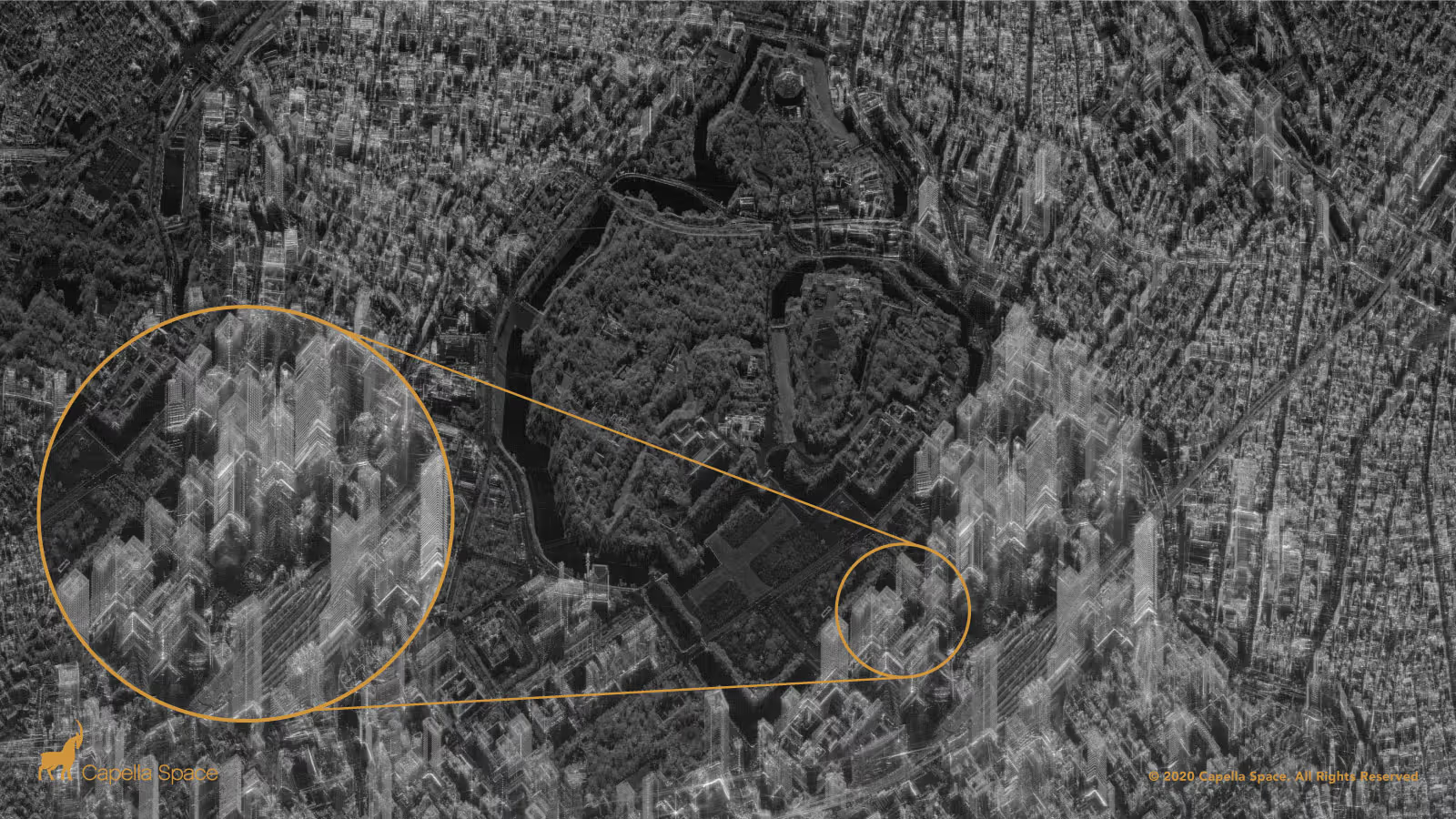
SAR is very different from the optical photographs that are built for interpretation by the human eye and we will explain why a ghost-like image of Tokyo is actually an artifact of SAR imagery distortion and not an “X-Ray of a City”.
The Myth of the Transparent Building
SAR does not see through buildings. It can image through extreme weather events, clouds, volcanic ash and other atmospheric conditions — but it will not image through a building.
But why do the buildings appear transparent?
To understand SAR data you need to think like a SAR analyst and realize the most fundamental fact about SAR: You are not looking at a photograph of Tokyo. What appears as a black and white optical satellite image is, in reality, a visual representation of the radar data — the reflectance of radio waves against the Earth’s surface and manmade objects.
Every object will reflect differently. Water will scatter away energy and appear dark in SAR imagery. Metallic surfaces shine brightly. One of the most unintuitive artifacts in SAR is the Layover Effect, where taller objects, such as mountains or skyscrapers, appear to layover onto others. As you can see in Tokyo, the skyscrapers of Chiyoda City are most distinguishable at their uppermost sections. SAR measurements quantify the distance from the satellite to the observed area. However, the middle sections of the city are almost woven together as multiple skyscrapers are simultaneously returning data to the satellite and overlaid on top of one another, creating the ghost-like effect.
This an image distortion known by professional SAR analysts — not a cross-section of a building.

As you can see in the above diagrams, objects are identified by their distance from the radar, not their distance projected ono the ground. Taller objects have certain points that are closer to the radar than some shorter objects that may be closer on the ground. When we project a radar image onto the ground, this phenomenon ends up distorting the image.
One of our radar scientists accurately described the phenomenon: It helps to think of it just as your brain’s interpretation of a two dimensional representation of the coherent sum of backscatter responses from electromagnetic waves.
If you would like to learn more about SAR and imagery distortions, please read our SAR 101.
SAR is Privacy Friendly!
Our satellites and operations are built fully mindful of the many government regulations that ensure SAR as a private and secure tool for better decision making that lead to better humanitarian and economic outcomes.
There are various government regulations to which we are accountable: including ITAR requirements, NOAA, and FCC licensing to name a few. One such regulation comes from the U.S. Commerce Department which limits the resolution, or number of pixels, in commercial SAR technology. The government currently permits 50 cm resolution, allowing us to detect objects as small as ships, aircraft, railcars and other vehicles. This allows our customers to meaningfully generate insights about the world:
- Inundated areas after a hurricane can reveal where flooding has occurred and enable efficient deployment of emergency resources.
- Illegal fishing vessels can be easily detected and maritime borders secured.
- The number of mining trucks in an open pit reveals information on extraction activities.

This provides an approximate level of detail and insight into how SAR is used every day.
What it cannot do at 50 cm resolution is see people, license plates or reveal any personally identifiable information (PII). Unlike other technologies that have recently been under scrutiny for privacy infringement such as cell phone geolocation data or automatic license plate readers (ALPR), SAR imaging specializes in a macro view of the world to see the general patterns of life.
It’s also more than capabilities — it’s about ethics. We don’t want to track individuals. Our company was founded on the belief that technology in space can significantly benefit life on Earth, and invading privacy does not help that mission.
Part of that also means thoroughly vetting our customers and partners to ensure they will use our information for ethical purposes.
Look Again
SAR is a wonderful tool that has provided science and researchers with life-saving information for decades. We are proud to be a part of this history with the highest resolution imagery commercially available and want to further educate the market. Without these resources, misinformation can unfortunately hinder scientific progress.
If you found this explanation helpful or would like to learn more, please do not hesitate to contact us.
Curious Which Of Our Analytics Partners
Can Support Your Mission?
Contact our team to explore the possibilities. Our experts can help
you determine the optimal solutions for your unique needs.

Keywords

Stay Informed. Stay Ready.
Get briefings on new capabilities, technology improvements, and upcoming events.


.avif)
