Scott Staniewicz
Blog
May 5, 2026
For nearly a decade, our customers have built products on the amplitude of our SAR images — the half that looks like an aerial photograph. Yesterday, we announced something new: commercially tasked, high-resolution InSAR, built on the phase of the signal that most users of commercial SAR have, until now, set aside.
Every SAR pixel carries both an amplitude, the portion of the radar return that looks like a crisp aerial photograph, and a phase, the position within the radar wavelength at which the echo returned. The phase of any single SAR image looks like pure noise; but, after carefully aligning two SAR images taken from the same orbital geometry, those phases can be differenced to form an interferogram: a map of how the ground moved between the two passes with a sensitivity to a fraction of the radar wavelength.
See InSAR 101 to learn the basics about InSAR and how it works.
Today, we’re going dive into what’s so distinctive about Capella's InSAR: coherence that holds across multi-year baselines, a 3-day revisit from our mid-inclination orbit, and resolution dense enough to resolve individual buildings, pits, and assets.
Coherence That Holds, Pass After Pass
A single interferogram has its uses, but the real product of InSAR is a stack of tens to hundreds of acquisitions, processed jointly to suppress atmospheric and decorrelation noise. Building stacks like that demands more than frequent collection: the satellite has to return to the same orbital tube, scene after scene, year after year. Our recent post on orbital precision covers how the Acadia constellation does this.
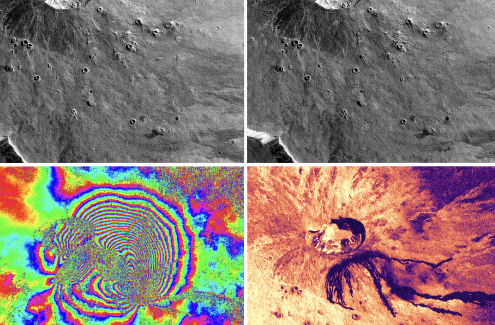
The visible result is interferometric coherence — the agreement of the radar return between two passes — that holds across long temporal baselines. Below, we show two interferograms over Rosamond, CA: one spans just under 3 days, another was created from images separated by 428 days. In the center of the lake, the ground changes rapidly, leading to speckle-y, “static-like” noise in the phase. This decorrelation is expected at X-band for surfaces undergoing constant change. But, in the surrounding desert area, we see that our interferogram phase is nearly as high quality after 400 days as after 3 days.

A 3-day Revisit Sees What Amplitude Can't
Capella-13 flies in a 53°-inclined mid-inclination orbit (MIO) with a 2.95-day repeating ground track. That means we can make a new interferogram over a target every three days, per geometry — which can mean 3-6 opportunities for every 3 day period. The leading commercial SAR constellations today offer 6-day, and 12-day repeat cycles. At 3 days, Capella can track events that evolve faster than those missions can follow.
The 2025–2026 eruptive sequence at Piton de la Fournaise (Réunion Island) is a clear example of the benefit. Working with colleagues at the Institut de Physique du Globe de Paris (IPGP), we began tasking Capella-13 Stripmap acquisitions over the summit in late 2025, as the OVPF tracked rising seismicity and inflation. Over the following weeks, the data captured on 3-day intervals was essential to showing the brief 18 January 2026 eruption on the north flank, and the major eruption that began on 13 February and reached the Indian Ocean on 16 March.
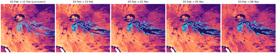
Where fresh lava advances, it completely decorrelates the radar return: coherence drops from near-1 to near-0 within a single 3-day pair, and the shape of the coherence drop traces the burn scar westward toward the sea. This signal is absent from the amplitude time series, where pre- and post-flow surfaces look nearly identical. Over the dike intrusions, the amplitude images are again visually unchanged, but the phase reveals a large signal from the opening fissures, with tens of centimeters of line-of-sight surface displacement.

A 12-day mission would, in the best case, capture one or two snapshots of a sequence like this. With a 3-day cadence we resolved the individual pulses, intrusion, eruption, pause, resumption, that defined the eruptive cycle.
Monitor What Matters
A reasonable question at this point is: 'Why not just wait for national space agency programs?' We're big fans of these missions — most of our analytics partners who use Capella also use public SAR data — and the global, free-and-open coverage of C-band and L-band programs is unmatched by any commercial small-sat constellation. For regional-scale monitoring at 5–20m resolution and a 6–12-day cadence, those missions are the right tool.
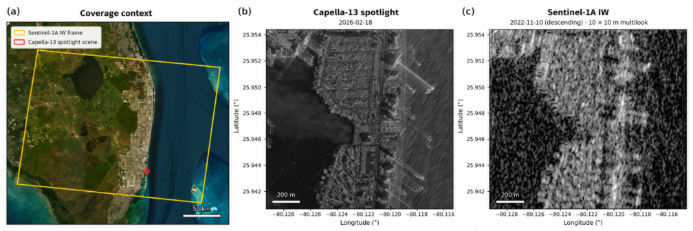
Capella's InSAR is complementary, and it earns its place at the asset scale and at cadences faster than public missions can offer. A single national program resolution cell covers most of a city block; a Capella 25-cm spotlight image contains hundreds of resolution cells over the same block and yields hundreds of high-quality persistent scatterer (PS) measurement points per skyscraper, where a national program might give you one.
High-Resolution PS Density Over Miami
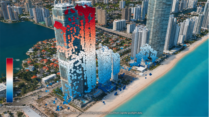
Below, we show a 3D view of the estimated pixel heights derived from a persistent scatterer interferometry (PSI) analysis of stack of 60 Capella spotlight acquisitions with 25-cm resolution over Miami. The joint estimate of line-of-sight velocity and scatterer height recovers the known elevation of the Porsche Design Tower to within 5% — consistent with the sub-meter precision of PS height estimation demonstrated by GAMMA Remote Sensing over Mexico City. That measurement-point density from Capella’s high resolution imagery is what enables reliable building-, pit-, and asset-level InSAR monitoring.
Background and targeted, in one picture
Free, regional-scale displacement products, such as the European Ground Motion Service (EGMS) over Europe and OPERA Surface Displacement from Sentinel-1 over North America, already give analysts a strong baseline picture of what the ground is doing at hundred-meter scales. Capella's contribution is the targeted, high-resolution layer on top: tasked at the cadence and viewing geometry that the asset demands, with the orbital precision needed to make the phase usable.
Curious Which Of Our Analytics Partners
Can Support Your Mission?
Contact our team to explore the possibilities. Our experts can help
you determine the optimal solutions for your unique needs.

Keywords
.avif)

Stay Informed. Stay Ready.
Get briefings on new capabilities, technology improvements, and upcoming events.


.avif)
